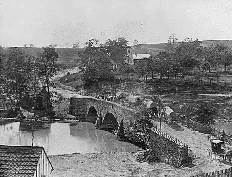
The Boonsboro Turnpike runs west from Boonsboro to Sharpsburg, directly through Lee's Center. In 1862, it was a major transportation artery, crossing the Antietam Creek at what is now known as the middle bridge, as shown in the wartime photograph above. It is the only road which gave McClellan direct access to the Confederate position; Federal troops had to wade the Antietam Creek and cross rolling farmfields to reach positions such as the Cornfield, the Sunken Road, and the Otto Farm. Yet, McClellan never made any serious attempt to cross the middle bridge and launch a direct attack on Lee's center. Failure to do so is often considered one of McClellan's biggest mistakes and greatest missed opportunities.
This study will not attempt to consider the odds of success for such a maneuver, the number of Federal troops that were ready for such a move or the number of Confederates that were available to resist it; those issue have already been discussed in the Campaign Histories. Instead, here we will consider that, if such a maneuver were attempted, what kinds of terrain would Union troops have to cross, and what obstacles would they need to cope with. On paper, it's hard to see how McClellan could fail: a very good bridge and a very good road led directly to Lee's weakest-held position. A close look at the terrain, however, reveals that it would not be quite that simple. The fields between the middle bridge and Sharpsburg are rough and would be difficult to cross. Also, Confederate troops held very good high ground that guard the approaches of the Boonsboro Turnpike. Had McClellan launched an attack across the middle bridge, it would not have been as simple an advance as many of his critics have supposed.
See Boonsboro Turnpike Photo Set.
See 3-D image of the Boonsboro Turnpike Region, looking westward.
See 3-D image of the Boonsboro Turnpike Region, looking eastward.
See Elevation Contour Map of the Boonsboro Turnpike Region