The action at the Otto farm marks the final phase of the Battle of Antietam. After taking the Lower Bridge at about 1:00 PM, the Union IX corps spent two hours crossing and reorganizing on the west bank of the creek. At about 3:00 PM, the last Union offensive of the day was launched; the attack intended to hit the Confederate right flank and take Sharpsburg from the south.
The IX corps vastly outnumbered the Confederates who faced them. That morning Lee had already stripped troops from this sector in order to bolster his left flank; all that the Confederates could hope for was to slow the Union advance. If the IX corps was not stopped, Lee's right flank would be rolled up; he would be cut off from the Shepherdstown Road, the only route of escape back to Virginia. Lee held one last card in his hand: he knew that A.P. Hill's division was coming up from Harper's Ferry, and should arrive any moment.
For the first hour, the Federals pushed ahead slowly but steadily. The rugged ground crossed by the advance offered many opportunities for defense. Nonetheless, the Federal drive could not be stopped. At around 4:00 PM, however, the Federal advance began to unwind. Because of a mix up in orders, the brigade on the extreme Union left failed to advance properly; this left the left flank exposed in a large treacherous cornfield - Otto's 40 acre cornfield. Much to their misfortune, advance elements of A.P. Hill's division surprised the Union flank at this critical time, and fell on the disorganized Federals from the south and west. Federal commanders tried to fill the widening gap, but Hill's attack was too fast and furious: the Union left flank fell back, obligating the right flank on the Rohrbach road, just on the outskirts of Sharpsburg, to follow. Losing the initiative, the Federals retreated back toward the Lower Bridge. In failing daylight, the battle ended.
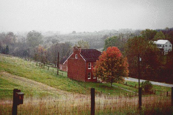
The above picture shows the red Sherrick farmhouse from behind; the white Otto farmhouse is across the road on the right. Christ's brigade, the right wing of the Federal movement, crossed the ground where this image was taken. Both the Sherrick and Otto farmhouses are now part of the Antietam National Battlefield Park. Neither is open to the public, but both are currently undergoing extensive renovations.
See 3-D image of the Otto Farm region.
See Profile Map of the approaches of the Union IX Corps.
See Elevation Map of the Otto Farm region.