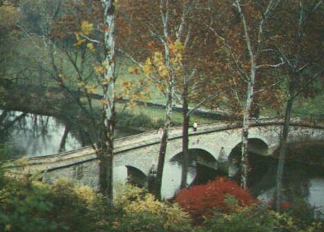
The Lower Bridge goes by many names. Locally it was known as the Rohrbach Bridge after the farm stead located just to the northeast; the road which passes over the bridge was also known as the Rohrbach Road. The bridge is also known as the Burnside Bridge, in reference to the Union IX Corps commander who was charged with overseeing the operation to assault the Confederate right wing. I choose to use the name The Lower Bridge because it avoids the often exaggerated role that General Burnside played in the action here, and because it fits in well with the naming scheme for the other bridges (Upper and Middle). Referring to the bridges by their geographic orientation on a map is itself consistent with the way the North, East, and West Woods of the northern portion of the battlefield are named.
This bridge was built sometime in the 1830's, and remained in service until the 1960's when a bypass was built to take traffic across the creek a little north of here. The bridge itself and the immediate vicinity are in a remarkable state of preservation.
The Union assault to take this bridge is perhaps among the most controversial topics of Antietam. The details on whether McClellan was lax in ordering a coordinated assault here in parallel with the assault on the Confederate left or if Burnside was tardy in directing the assault, and whether the bridge itself was worth taking or if other fords were available or even needed, and many other issues, can be found in the Campaign Histories. Suffice to say, at a time when Lee was striping this portion of the battlefield in order to send reinforcements to his left wing, the Union troops here conducted halfhearted, uncoordinated, and uninspiring attempts to take the bridge. As a result, about 500 Confederates were able to hold back about 9,000 Union troops for several hours. As will be discussed in the next tour stop, these several hours were absolutely crucial to Lee.
One element of the controversy will be covered here: the tactical significance of the ground. At first glance the fact of 500 holding off 9,000 can only be explained by incompetence on the Union part. It is not until the ground here is examined that one can really appreciate what the Union troops had to cope with.
See 3-D image of the Lower Bridge Region
See Profile Map of the path of the Union assault