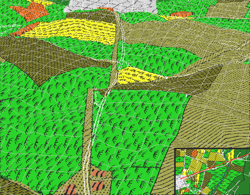
From this view, we are situated above the Federal position on the east of the Antietam looking westward toward the town of Sharpsburg. The Boonsboro Turnpike runs from the bottom to the top of the image. Note that the modern trace of the turnpike (in white) does not follow the historic trace (in brown). The Newcomer farm is in the immediate foreground; the two farmhouses on the right of the turnpike, the barn on the left (a discussion of the Newcomer farm can be found in Frassanito, p90). The upper left of the image marks the location of the Sherrick fields. The upper right of th image is the Piper farm.
The main feature visible from this vantage point is the large cigar-shaped (as seen from above) hill that separates the Newcomer farm from the Sharpsburg region. This hill can be seen rising up about midway on the right hand side of the image (about the 7th contour line from the bottom of the image), cresting along the eastern edge of the stubble field in the middle of the image, and then falling off rapidly just to the left of the turnpike. This hill would have been a detriment to Federal troops approaching Sharpsburg: in addition to being yet another obstacle to cross, Federal soldiers would have made excellent targets for Confederate guns on the much higher ground to the west.
Beyond the Newcomer farm, the turnpike is covered by two large hills: Cemetery Hill and another hill on the right, on the Piper farm. The turnpike scales Cemetery Hill, and is flanked by the Piper Hill on the right, as one approaches Sharpsburg. Both hills were occupied by Confederate artillery and infantry during the afternoon of the 17th.
The ground in the immediate foreground was occupied by Federal cavalry and horse artillery. At about noon, these Federal troopers crossed the middle bridge and took up a line fanning out along the crest of the cigar-shaped hill to the left and right of the turnpike, eventually pushing skirmishers west of the hill, where they exchanged heavy fire with Confederate troops on Piper's Hill.
Today, it is hard for visitors to the battlefield to appreciate the magnitude of the cigar-shaped hill. As can be seen in the image, the modern version of the turnpike is heavily graded and runs through a deep cut in the hill, robbing it of some of its height. The original trace of the turnpike skirted the southern edge of the hill, and is now the site of the Antietam picnic area. To get a true feel of what the road to Sharpsburg would have been, the battlefield visitor should walk westward up Maryland route 34 (the modern designation of the turnpike) from the middle bridge, and veer to the left and follow the road up to the picnic area. The climb will be significantly more rugged than following route 34 directly to Sharpsburg.