 This map shows the elevation profiles of three different paths taken
by the
Union IX Corps
in their assault on the Confederate right flank.
Each path is drawn on the lower map (red, blue, and orange lines), and
the corresponding elevation profile is drawn above.
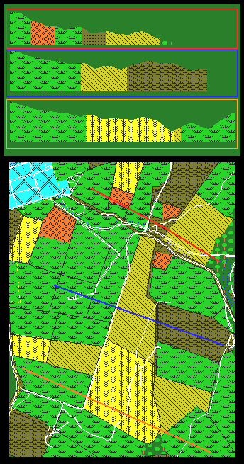
This map shows the elevation profiles of three different paths taken
by the
Union IX Corps
in their assault on the Confederate right flank.
Each path is drawn on the lower map (red, blue, and orange lines), and
the corresponding elevation profile is drawn above.
The red path represents the route taken by Christ's Brigade. Compared to the other two paths, Christ's Brigade has the shortest, but steepest of the three.
The blue path represents the route taken by Fairchild's Brigade. Readily discernible is the steep climb out of Otto's plowed field. The real climb, however, is across the open fields west of the plowed field.
The orange path represents the route the the Union IX Corps left flank (Harland's Brigade) might have taken had its movement been successful. As it happened, Harland's troops descended into the hollow that stretches across the 40 Acre Cornfield (the lowest point on the profile, on the southeastern portion of the cornfield; see the elevation map for the shape of the hollow) when Confederate troops of A.P. Hill's Division came upon them from the high ground on the west and south. The situation could hardly have been worse for the Federals - they were taken in surprise; one of the regiments (the 16th Connecticut) had no combat experience, having joined the service only three weeks before; they were caught in the hollow of a very rugged, tall cornfield, with minimal visibility and overwhelming confusion. Although they put up valiant resistance, Harland's troops could not hold up to the Confederate attack, and they began to stream eastward out of the corn.