 This is an elevation contour map of the region around the Otto Farm.
The elevation of each point is encoded into a color and plotted;
outlines of familiar fields and fences are overlayed in black.
The colors and their corresponding elevations are summarized in this table:
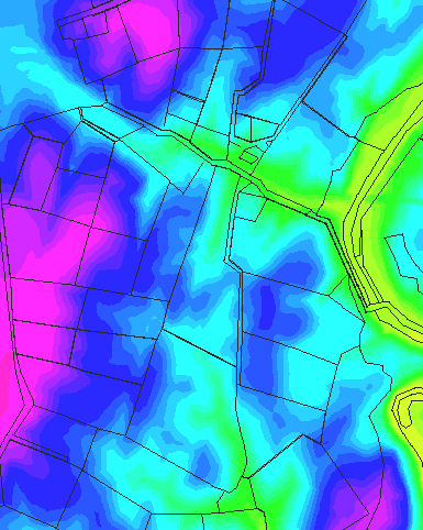
This is an elevation contour map of the region around the Otto Farm.
The elevation of each point is encoded into a color and plotted;
outlines of familiar fields and fences are overlayed in black.
The colors and their corresponding elevations are summarized in this table:
| Color | Approximate Elevation |
|---|---|
| Yellow | 300-320 |
| Light Green | 320-380 |
| Aqua | 380-405 |
| Light Blue | 405-415 |
| Medium Blue | 415-425 |
| Dark Blue | 425-465 |
| Light Red | 465-500 |
| Dark Red | 500-515 |
All elevations are in meters.
In this image, the true nature of the terrain becomes apparent. Cemetery Hill and the ridge along the Harper's Ferry Road dominate the region. The irregular topography of the 40 Acre Cornfield, and the hollow which cuts across it, are clearly visible. Also visible is a ridge just east of Otto's Lane, which obstructs the line of sight for observers near the Lower Bridge.
After an examination of the facts, what appears on paper to be a simple jaunt through open fields, some corn and a few orchards, in reality turns out to be some very rugged terrain that would prove to be a challenge for any army, even one with numerical superiority.