Viewregion Line of Sight Analysis
Line of Sight (LOS) Analysis provides the means to determine what portions of the battlefield are visible from a given position on the battlefield.
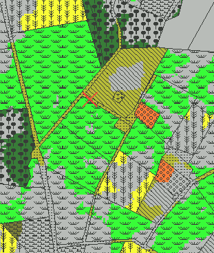
In the previous discussion about LOS, the analysis was based on viewpoint LOS analysis, that is, the visibility of each point surrounding a given point was considered. In practice, choosing the correct point from which to carry out the LOS analysis is difficult. Consider Figure X.1:
|
|
|
| (a) | (b) |
| Figure X.1 | |
In figure X.1 (a), a viewpoint based LOS map is generated with respect to the point indicated by the 'X'; this point is very near the significant terrain feature known as the Battlefield Divide. From this point, the view is extensive.
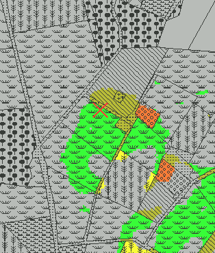
Figure X.1 (b) represents the area visible from a viewpoint a mere 75 meters distant from that in (a). The difference is that in (a), the viewpoint is close enough to the crest of the Battlefield Divide ridge to see over and beyond it, whereas the view in (b) cannot see over this ridge, so everything to the north and west is blocked. The difference between these two images illustrates how the area of visibility with respect to a specific viewpoint is very sensitive to the selection of that viewpoint.
For a more general assessment of LOS, viewpoint LOS analysis is replaced with viewregion LOS. In viewregion LOS, one selects a set of points (instead of just a single point, as in viewpoint LOS) called the viewregion, and each point on the map is assessed with respect to each point in the viewregion, and assigned a percentile value as to how many points in the viewregion have LOS with that point. For example, if a given point on the map has LOS with 40 out of 60 points in the chosen viewregion, then that point is assigned a value of 66. The higher the percentile rank, the more points in the viewregion that have LOS with that point. If a point on the map has LOS with no points in the viewregion, then it has a value of zero.
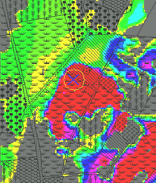
Figure X.2 illustrates viewregion LOS.
|
|
|||
| (a) | (b) | |||
| Figure X.2 | ||||
In Figure X.2 (a), the map is redrawn as a viewregion LOS map, with the viewregion defined as the 75 meter radius circular region surrounding the point marked as X, the same point considered in Figure X.1 (b). Figure X.2 (b) shows the color coded scale used to interpret X.1 (a). One can easily grasp the extent of the visibility from the various locations within the circular viewregion.
For example, from Figure X.1 (a), we knew that some points in the viewregion of X.2 (a) would have LOS with the Dunker Church. Since the Dunker Church region in X.2 (a) is shaded with a light green, however, we can conclude that few locations in the viewregion have LOS with the Dunker Church (the actual value is 18.2%). If we knew that at a certain moment 5 artillery pieces were distributed in this viewregion, we would expect that only 1 would have LOS with the Dunker Church.
The selection of the viewregion can be any size or shape, and could even be a collection is discontiguous subregions. In practice, however, the selection of the viewregion would correspond to the ground occupied by a military unit, such as a regiment or a battery of artillery. Using viewregion LOS, one could then determine how much (if any) firepower could be directed to an enemy at some arbitrary location.