|
|
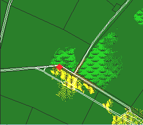
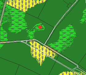
These two Line of Sight images illustrate how the terrain around the Sunken Road region severely limits visibility. Each image shows approximately what is visible from the point marked by the red diamond; historic fencelines and modern roads are also shown for orientation.
The image on the left represents the point of view from inside the road, near the 'angle'. The ground to the west rises steeply, obscuring everything in that direction. The ground falls away to the south/southeast, and is also hidden. Only the southern face of Kimball's Knoll, and the region just east of Roulette's lane is really visible from this point. The Sunken Road offers a trench-like position, but, by its nature, also limits visibility of its occupants.
The image on the right represents the point of view from the high ground of Kimball's Knoll. The disadvantage of being on a flat hill is that everything around the base is obscured. Only small segments of the Sunken Road are visible from here, although there is clear line of fire to the Confederate ranks set behind the road in Piper's cornfield.
As can be seen, even at close distance, good line of sight is hard to get. This is one of the reasons why the fighting here was so fierce - troops had to get right up close to fire on each other.