What is a GIS?
A Geographic Information System (GIS) is a software package designed to support the capture, management, analysis, modeling, and display of spatially referenced data. Spatially referenced data simply means that the data quantifies some attribute of points on the Earth's surface. The type of data quantified can take many forms - vegetation cover, elevation, slope, average annual rainfall, census, etc. Once the desired data that describes the features of a landscape are imported into the GIS, the software can be used to study and analyze that landscape.
There are many GISs available, but they all have a few things in common. A few common principals among GISs is that the operator can first select a geographic region of interest. This region is divided up into smaller rectangular units called cells. When a landscape's data is imported into the GIS, each cell in the region is set to some numeric value that describes the landscape at that cell's location. Data organized in this fashion is called a raster map. Typically, the data is of 2 forms: either some kind of encoding is used, or the data represents some real aspect.
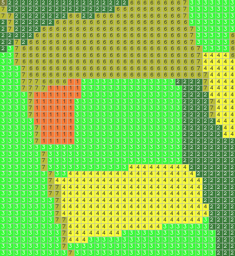
For example, in Figure 1 below we have an image that depicts the region on the battlefield between the Miller Cornfield and the North Woods. A grid is displayed, showing the boundaries of each cell. Inside each cell, we see a value that describes the type of terrain that that cell occupies:
|
| Figure X.1 |
Each cell is encoded with some value that describes some aspect
of the landscape.
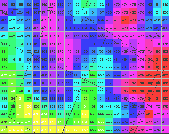
On the other hand, the data can be such that it actually describes real data about the ground the cell occupies. For example, in Figure 2 we have the region on the Piper farm, the Sunken Road running along the top and right of the image. This map represents topographical elevation, stated in feet above sea level. Each cell contain a value that represents the average elevation of the ground occupied by that cell.
 |
| Figure X.2 |
Of great importance is the cell size, or resolution, usually stated in terms of the length of a cell's side. In figure 1, the cell size is 20 meters, meaning each cell represents a 20mx20m chunk of real estate. In figure 2, cell size is 30 meters. Obviously, as the cell size decreases, the data becomes finer and more detailed. On the other hand, as the cell size is decreased, the amount of data needed to represent a given region increases dramatically since the number of cells increases; if the cell size is cut in half, the total number of cells will increase fourfold. Typically, the initial survey which generates the data will be at some given resolution, and that determines the smallest cell size the data can be used at.
The advantage to the raster map concept is that once the landscape has been quantified into a set of cells, a variety of different kinds of calculations can be easily performed on the landscape. For example, in figure 1, we can calculate the approximate area of the Miller cornfield by noting the cell size is 20 meters, and then counting the number of cells which is occupies. Since there are 202 Miller Cornfield cells, the total size is 202 cells x 400 square meters/cell, or 80,800 square meters, or about 20 acres. As a second example, for the Piper farm region shown in figure 2, we could determine the difference between the highest and lowest points; examining the map we see the maximum value is 485 feet and the minimum value is 428 feet, making the total variation in elevation 57 feet.
These examples are trivial, but they are meant to illustrate some of the basic concepts. In later lessons, we will see how a GIS can be used to calculate diverse problems such as how water drains across a landscape, what ground an observer can see from a given location, how rugged is 1 region compared to another. The solutions to these problems will provide insight on how the terrain of the battlefield affected the movements and operations of the two armies which fought there.