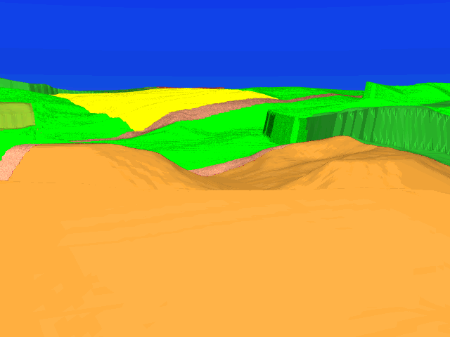
 Nicodemus Heights is the site of the Confederate Horse Artillery under
John Pelham during the opening hours of the battle.
These heights offered a sweeping view of the ground between the
East and West Woods.
In this image, the view is directed toward the Miller Cornfield.
The Northern portion of the West Woods is visible on the right.
The Hagerstown Turnpike can be seen climbing up and over
the rise on which the western portion of the Cornfield is situated.
Nicodemus Heights is the site of the Confederate Horse Artillery under
John Pelham during the opening hours of the battle.
These heights offered a sweeping view of the ground between the
East and West Woods.
In this image, the view is directed toward the Miller Cornfield.
The Northern portion of the West Woods is visible on the right.
The Hagerstown Turnpike can be seen climbing up and over
the rise on which the western portion of the Cornfield is situated.
From 6:00 am to 8:30 am Union and Confederate forces hammered away at each other in order to control the Miller farm. By 9:00 am, Federal troops had gained superiority and the northern portion of the Miller farm - including the Cornfield - fell into Federal hands. As the line of battle moved southward, Pelham's artillery relocated to Hauser's Ridge, directly west of the Dunker Church.
Union troops never made any concerted effort to take possession of Nicodemus Heights.
Note that despite the superior position of Nicodemus Heights, no portion of the Middle portion of the battlefield - the Mumma farm, the Roulette farm, the Sunken Road, etc - is visible from here. The Mumma farm lies toward the mid right of the image, but from this vantage point it is below the horizon. While not obvious from the ground, the Miller farm is situated on ground that is considerably higher than that occupied by the Mumma farm. Consequently, not even observers on Nicodemus Heights can see what is going on south of the Dunker Church. This kind of analysis of the ground explains how Antietam breaks into the three (northern, middle, and southern) distinct regions of action: each is geographically isolated from the other.